How To Access GeoFS Online Flight Simulator
 The world of flight simulation offers a unique blend of excitement, education, and exploration, and one of the most accessible platforms for experiencing this is the GeoFS online flight simulator. With its user-friendly interface, realistic flight dynamics, and engaging global scenery, GeoFS allows both beginners and experienced pilots to take to the skies without the need for expensive software or hardware. This guide will provide an in-depth look at how to play GeoFS, covering everything from setup to advanced flying techniques.
What is GeoFS Online Flight Simulator?
GeoFS online flight simulator is a web-based platform that allows users to fly various aircraft in a detailed, global environment. Developed to be accessible from any modern web browser, GeoFS removes the barriers associated with traditional flight simulators. Whether you’re a casual gamer, a student of aviation, or someone simply interested in the mechanics of flight, GeoFS provides a rich and engaging experience.
Getting started: Setting up your account
Accessing GeoFS:
To begin your journey with GeoFS, all you need is a device with internet access and a compatible web browser. Head to the GeoFS website, where you can start flying immediately without any downloads. While you can explore the simulator without an account, creating one offers several benefits, such as saving your flight data and customizing your experience.
Creating your account
-
- Visit the GeoFS website: Go to the official GeoFS website.
- Sign up: Look for the account creation option, usually located in the top navigation bar. You’ll need to provide a username, email address, and password.
- Verify your account: Check your email for a verification link and click on it to activate your account.
Once your account is set up, you can log in and access additional features that enhance your flying experience.
Understanding the user interface
Dashboard overview
Upon logging in, you will be greeted by the GeoFS dashboard. Familiarizing yourself with this interface is crucial for a smooth flying experience. Key components of the dashboard include:
-
- Aircraft selection: A menu where you can choose from various aircraft types, ranging from small planes to large commercial jets.
- Location settings: Options to select your departure airport or geographical area for flight.
- Weather conditions: Settings to customise weather elements such as wind speed, cloud cover, and visibility.
- Flight controls: Access to the flight controls, including throttle, flaps, and landing gear.
Controls layout
Understanding the control layout is essential for effective navigation and operation of your aircraft. Most flight controls can be managed using your keyboard and mouse, but you can also connect a joystick or yoke for a more realistic experience.
-
- Throttle: Adjusts the power of the aircraft’s engines.
- Ailerons: Controlled by the left and right arrow keys or joystick; used for rolling the aircraft.
- Elevator: Controlled by the up and down arrow keys; adjusts the pitch of the aircraft.
- Rudder: Used for yawing the aircraft, often controlled by specific keyboard keys or joystick.
Choosing your aircraft and location
Aircraft selection
The joy of the GeoFS online flight simulator is the variety of aircraft available. As a beginner, you might want to start with a simple general aviation aircraft, such as a Cessna 172. More experienced pilots can explore complex commercial jets or even military aircraft.
Selecting a departure location
Once you have chosen your aircraft, the next step is to select your departure location. GeoFS offers a wide range of airports and geographical areas around the world. You can fly from well-known airports, such as Los Angeles International or London Heathrow, or explore remote airstrips in picturesque landscapes.
-
- Search feature: Use the search bar to quickly find airports by name or code.
- Map navigation: You can also zoom in on the world map to select a location visually.
Preparing for takeoff
Pre-flight checks
Before you take off, performing pre-flight checks is crucial. Ensure that:
-
- Fuel load: Your aircraft has an adequate fuel load for your intended flight.
- Flight plan: If you’re planning a specific route, consider plotting waypoints to guide your flight.
- Weather conditions: Check the current weather conditions for your chosen departure and arrival locations.
Taxiing and takeoff
Once you are ready, follow these steps for taxiing and taking off:
-
- Start the engines: Use the control panel to start your aircraft’s engines.
- Taxi to the runway: Use your controls to manoeuvre the aircraft to the active runway. Make sure to follow standard taxiing procedures.
- Line up: Position your aircraft on the runway and ensure it is aligned with the centerline.
- Throttle up: Gradually increase the throttle to initiate takeoff. Monitor your speed closely.
- Lift off: Once you reach the appropriate speed (commonly around 70-80 knots for small aircraft), pull back on the elevator control to lift off.
In-flight operations
Basic flight manoeuvres
Once airborne, you can begin practicing basic flight maneuvers. Here are some fundamental techniques to get you started:
-
- Climbing and descending: To climb, gently pull back on the elevator control while increasing throttle. For descending, reduce throttle and lower the nose slightly.
- Turning: Use the ailerons to bank the aircraft in the direction you want to turn while coordinating with the rudder for a smooth manoeuvre.
- Level flight: Adjust the throttle and pitch to maintain a consistent altitude and speed.
Navigation basics
Understanding navigation is essential for successful flight:
-
- Use of waypoints: You can create waypoints using the map feature to guide your flight path.
- Visual landmarks: Familiarize yourself with visual landmarks on the ground to assist in navigation.
- Altitude settings: Adjust your altitude as necessary to comply with air traffic control or your flight plan.
Advanced flight techniques
Instrument flying
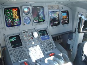
As you become more comfortable with basic flying, consider learning instrument flying techniques. This involves using the aircraft’s instruments for navigation and control rather than relying solely on visual references. Key instruments to understand include:
-
- Airspeed indicator: Monitors your current speed.
- Altimeter: Measures your altitude above sea level.
- Artificial horizon: Helps maintain level flight.
Weather management
GeoFS allows users to experience various weather conditions. Learning to navigate and manage different weather scenarios is essential for becoming a proficient pilot:
-
- Flying in clouds: Use your instruments to maintain control and altitude when flying through clouds.
- Adapting to wind: Be prepared to adjust your flight path and speed based on wind conditions.
Landing your aircraft
Preparing for approach
As you near your destination, it’s time to prepare for landing:
-
- Communicate: If using multiplayer mode, communicate your intentions to other pilots.
- Check weather and runway: Confirm current weather conditions at your destination and select the appropriate runway.
- Reduce speed: Begin to reduce speed and altitude gradually.
Landing process
-
- Final approach: Align your aircraft with the runway and maintain a steady descent.
- Flaps deployment: Deploy flaps to increase lift and slow down your descent rate.
- Touchdown: Aim for a smooth touchdown by gently pulling back on the elevator control just before landing.
Taxiing to parking
After a successful landing, taxi your aircraft to the designated parking area following standard procedures. Ensure you communicate your movements if in multiplayer mode.
Engaging with the GeoFS Community
Connecting with other pilots: The most rewarding aspects of playing GeoFS online flight simulator is the community of aviation enthusiasts. Engage with fellow pilots through forums and social media groups. Sharing experiences, tips, and flight plans can enhance your learning experience.
Participating in events: GeoFS often hosts events and challenges that allow users to test their skills and interact with others. Participating in these events can provide additional motivation and improve your flying skills.
Troubleshooting common issues
Connectivity problems: If you experience connectivity issues while using GeoFS, consider checking your internet connection or trying a different browser.
Performance lag: If the simulator is lagging, you may want to lower your graphics settings or close other applications to free up resources.
Aircraft control issues: If you are having trouble with aircraft controls, revisit the control settings to ensure everything is configured correctly. You can also consult community forums for troubleshooting tips.
Future of your flight simulation journey
As you become more comfortable with GeoFS and flight simulation, consider exploring more advanced topics:
- Advanced navigation: Study aviation charts and learn about VFR and IFR navigation.
- Aircraft systems: Familiarise yourself with the systems of different aircraft types, such as avionics and engine management.
- Cross-country flying: Plan and execute longer flights to enhance your navigation and planning skills.
Conclusion
The GeoFS online flight simulator offers an engaging and accessible way for anyone to experience the thrill of flight. With its realistic flight dynamics, extensive aircraft selection, and vibrant community, GeoFS is a fantastic platform for both newcomers and seasoned pilots.
By following the steps outlined in this guide, you can embark on an exciting journey through the skies, developing your skills and knowledge as you go. So, fire up your engines, choose your aircraft, and get ready to explore the vast world of aviation through GeoFS.


